Wilhelmstraße
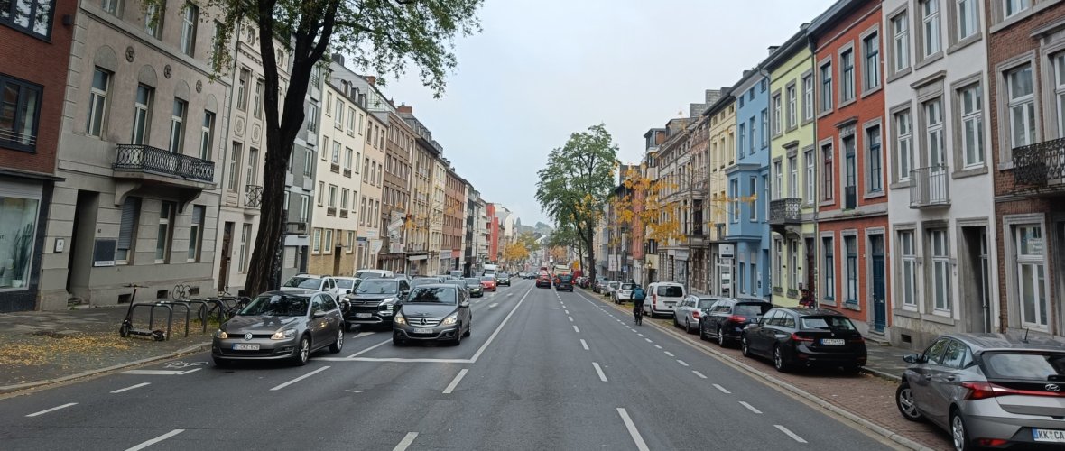
City of Aachen
Brief info
- Project: Redesign according to regional grid measure
- Objective: Cross-section in compliance with guidelines
- Timeline: starting in 2027
- Project phase: Preliminary planning
Current
On September 10, 2026, the Mobility Committee tasked the administration with conducting a public engagement process based on Options A and B, which are presented below. This dialogue is currently being prepared. As soon as details are finalized, they will be posted on this website.
Map
Occasion and goal
The sewer lines along the eastern ring road (Wilhelmstraße, Heinrichsallee, and Monheimsallee) are in urgent need of replacement. This work is scheduled to begin on Wilhelmstraße. As part of the sewer construction, the electricity, gas, and drinking water lines will also be replaced, and a district heating pipeline will be laid. Based on current information, these measures will cover the entire street right-of-way and will be carried out using open-cut construction methods. Once the underground work is complete, extensive surface restoration will therefore be required. As part of this restoration, the street layout could be redesigned to meet future needs. The current street layout no longer complies in all respects with the requirements of the regulations currently in effect.
Stock
As part of the Regionetz project, all road markings will be removed. However, since these markings no longer comply with current regulations (bicycle lanes that are too narrow, lack of safety separation strips, narrow motor vehicle lanes), the existing markings cannot be restored to their original condition. An alternative road layout must therefore be developed. Further details can be found in the linked document.
Planning
Extensive consideration was given to alternative cross-sections. From among these various options, four variants were selected for further planning analysis.
All options call for converting the current parking lanes into what are known as multifunctional lanes. This means that, in addition to parking spaces for cars and trees, the plan also includes bike racks, charging stations for electric vehicles, parking areas for e-scooters, and delivery and loading zones for both private and commercial use.
Option A (Elimination of the bike lanes)
The bike lanes—some of which are too narrow and lack a safety buffer zone separating them from parked vehicles—will not be reinstated after the sewer renovation. This will allow for the marking of traffic lanes with nearly ideal dimensions. Bicycle traffic will be routed together with motor vehicle traffic in a mixed-use setting. According to the Recommendations for Bicycle Infrastructure (ERA), this routing method is not recommended under the existing conditions (motor vehicle traffic volume and speed). If it is nevertheless to be considered, the regulations stipulate that an additional alternative route should be provided. In the case of Wilhelmstraße, the connection via Friedrichstraße should therefore be significantly improved (possibly by designating it a “bicycle street”). The route to the alternative route from the Kaiserplatz and Normaluhr intersections must also be clearly marked.
Option B (Uphill Bike Lane)
Building on Option A, a dedicated bike lane will also be added in the direction of travel corresponding to the 12 o'clock position on a clock. In this direction, the street has a significant incline, which leads to a greater difference in speed between bicycle and motor vehicle traffic and thus a greater need for (at least spatial) separation of the different modes of traffic. Toward Kaiserplatz, cyclists share the roadway with mixed traffic. In this variant as well, upgrades to the parallel route via Friedrichstraße would need to be planned.
Option C (Uphill Bike Lane and Eco-Lane)
In Option C, the right-hand lane in the direction of Kaiserplatz becomes a bicycle lane open to public transit. This creates bicycle facilities for both directions and potentially speeds up bus travel. However, ASEAG has indicated in advance that it prefers Option B in a direct comparison, since the dedicated lane would have to be shared with bicycle traffic and, furthermore, such side lanes are often only usable to a limited extent due to vehicles parking illegally. That said, in Option B as well, the right-hand lane would have to be shared with bicycle traffic, and in all options, designated areas within the parking lane are planned for delivery and loading. In contrast to Option B, Option C includes a bicycle path leading toward Kaiserplatz. In this option, motorized individual transport (MIV) has two lanes available toward Normaluhr and one lane toward Kaiserplatz, which represents a restriction for the latter compared to the current situation.
Variant D (wide side aisles)
The roadway will be reduced to two lanes. Wide sidewalks and bike lanes that comply with the “Radentscheid” will be created in the adjacent area. Trees will be planted at a considerable distance from building facades, ensuring they have the best possible growing conditions. This option creates an attractive street environment; however, it meets the requirements for (motor vehicle) traffic less effectively than the other options. The high network importance of private motor vehicle traffic and public transit is not reflected in this option.
Assessment by the Administration
At present, there are many indications that Option B is the most effective planning approach, as it takes into account the high priority given to motorized individual transportation and public transit along the Alleenring, while also providing a basic infrastructure for bicycle traffic.
Council info template
Proposal for the Eastern Alleenring - FB 68/0100/WP19
: Necessary Work on Utility Lines and Public Space Design
Wilhelmstraße Planning Consultation - FB 68/0093/WP19
: Reallocation of street space in connection with the necessary sewer replacement
Download
Contact us
Search results are loaded
No employees found.