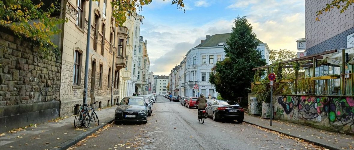
Lochnerstrasse

Brief info
- Project: Premium footpath Westpark and cycle priority route Vaals
- Objective: Promotion of cycling and walking, climate resilience
- Project phase: Preliminary planning
Current
On 10.07.2025, the Mobility Committee of the City of Aachen adopted the planning decision for variant C. Implementation is to take place in the course of the upcoming work on the supply and disposal lines. As soon as a more concrete timetable for this is known, this will be communicated on this website.
Occasion and goal
Lochnerstraße is part of the Aachen - Vaals cycle priority route (RVR). Cycle traffic should be routed safely, comfortably and swiftly in the cycle priority network. In addition, the premium footpath 8 between the Palatinate district and the Westpark crosses Lochnerstraße. The aim is to strengthen the offer for pedestrians on selected routes between the city center and the surrounding parks, stream valleys and park-like landscape areas.
Lochnerstrasse is also to be extensively equipped in terms of climate adaptation (heat and heavy rain prevention) with shade-giving trees and green structures.
Map
Condition
Lochnerstraße is already heavily used by pedestrians and cyclists. To the west of Junkerstrasse, the sidewalk is narrowed to 1.50 m at regular intervals by the existing tree grates. The surface is not in good condition due to root heaving and it is difficult to sustainably repair the existing sidewalk for tree protection reasons. To the east of Junkerstrasse, the road only has two trees set back in the widening area towards Karlsgraben.
Over the course of the day, quarter-hour intervals can often be observed in which more bicycles than cars use the road. However, the available lane is so narrow due to parking on both sides that it is only possible for two cars to pass each other when driving slowly, which also impairs cycling. In addition, cyclists often have to ride in the "docking" zone next to parked vehicles.
Planning
Three variants were developed, but they only differ to the east of Junkerstrasse.
To the west of Junkerstrasse, a new footpath will be created south of the row of plane trees in all variants; the existing footpath will be unsealed to allow better growing conditions for the trees and to create opportunities for seepage and evaporation. The diagonal parking will be converted into longitudinal parking. The junction area towards the Westpark will be raised as a plateau and provided with structural dividing elements that will structure the space and also serve as a place to linger.
Three variants were developed for the redesign of the eastern Lochnerstrasse.
All variants provide for a multifunctional strip (greenery, benches, delivery/shopping, car and bicycle parking) on the north side. The north side was chosen as it has more favorable light and thus growth conditions as well as higher cooling effects than the south side. All three variants improve air quality and reduce noise emissions.
In variant A, there is more parking space in the multifunctional strip; in variant B, more continuous green beds are provided instead. Variant C represents a middle way between variants A and B.
A detailed description of the variants can be found in the linked administrative document on the planning decision.
Bürger*innenbeteiligung
In the period from November 2 to 30, 2023, a public participation process was carried out for the redesign of Lochnerstrasse. On November 16, a dialog event was held in the KGS Hanbruch.
Costs
Based on current knowledge, it is not expected that residents will be involved in the conversion costs. Should this nevertheless be the case, there will be a separate information event.
Further information
Council info template
June 2025: Submission for planning decision (FB 68/0215/WP18)
Link: ALLRIS - Template
August 2023: Submission for public participation (FB 61/0713/WP18)
Link: ALLRIS template
Download
Contact us
City of Aachen by email: lochnerstrasse@mail.aachen.de